


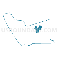
Voting District 10110, Alameda County, California
About
Outline

Summary
| Unique Area Identifier | 528661 |
| Name | Voting District 10110 |
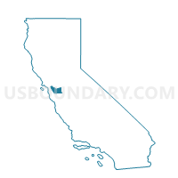
| County | Alameda County |
| State | California |
| Area (square miles) | 24.68 |
| Land Area (square miles) | 24.68 |
| Water Area (square miles) | 0.00 |
| % of Land Area | 99.99 |
| % of Water Area | 0.01 |
| Latitude of the Internal Point | 37.68832970 |
| Longtitude of the Internal Point | -121.76545110 |
Maps

Graphs
Select a template below for downloading or customizing gragh for Voting District 10110, Alameda County, California


Neighbors
Neighoring Voting District (by Name) Neighboring Voting District on the Map
- Voting District 10111, Alameda County, CA
- Voting District 10120, Alameda County, CA
- Voting District 10125, Alameda County, CA
- Voting District 10140, Alameda County, CA
- Voting District 10150, Alameda County, CA
- Voting District 10160, Alameda County, CA
- Voting District 10165, Alameda County, CA
- Voting District 10170, Alameda County, CA
- Voting District 10185, Alameda County, CA
- Voting District 10195, Alameda County, CA
- Voting District 10225, Alameda County, CA
- Voting District 10230, Alameda County, CA
- Voting District 10235, Alameda County, CA
- Voting District 10240, Alameda County, CA
- Voting District 10245, Alameda County, CA
- Voting District 10305, Alameda County, CA
- Voting District 10310, Alameda County, CA
- Voting District 10320, Alameda County, CA
- Voting District 10340, Alameda County, CA
- Voting District 10360, Alameda County, CA
- Voting District 10365, Alameda County, CA
Top 10 Neighboring County Subdivision (by Population) Neighboring County Subdivision on the Map
Top 10 Neighboring Place (by Population) Neighboring Place on the Map
Top 10 Neighboring Unified School District (by Population) Neighboring Unified School District on the Map
- Livermore Valley Joint Unified School District, CA (84,627)
- Pleasanton Unified School District, CA (70,714)
Top 10 Neighboring State Legislative District Lower Chamber (by Population) Neighboring State Legislative District Lower Chamber on the Map
- Assembly District 15, CA (591,194)
- Assembly District 18, CA (452,969)
- Assembly District 20, CA (445,046)
Top 10 Neighboring State Legislative District Upper Chamber (by Population) Neighboring State Legislative District Upper Chamber on the Map
Top 10 Neighboring 111th Congressional District (by Population) Neighboring 111th Congressional District on the Map
Top 10 Neighboring Census Tract (by Population) Neighboring Census Tract on the Map
- Census Tract 4507.01, Alameda County, CA (8,075)
- Census Tract 4511.01, Alameda County, CA (7,081)
- Census Tract 4514.04, Alameda County, CA (6,610)
- Census Tract 4512.01, Alameda County, CA (6,595)
- Census Tract 4513, Alameda County, CA (6,560)
- Census Tract 4516.02, Alameda County, CA (6,224)
- Census Tract 4514.01, Alameda County, CA (5,850)
- Census Tract 4515.03, Alameda County, CA (5,660)
- Census Tract 4507.52, Alameda County, CA (5,262)
- Census Tract 4515.01, Alameda County, CA (4,668)